
1898 Alaska Klondike Gold Rush Map Place-Mat
NOAA has made it easy for you to make Place-mats for gifts to friends.
You can download Historical Charts, maps and current Nautical Charts and for no charge from NOAA. The charts and maps can easily be cropped to place-mat proportions and printed then clear laminated. Coasters can also be made. Total cost was less than $ 5.- for each mat.
These make great gifts for boaters, make a place-mat of their favorite sailing area, historical aeronautical charts can be made for pilots and historic charts for history buffs. NOAA’s library goes back to the late 1700’s and includes city plots and Civil War Battles, in addition to the marine charts we associate with NOAA today.
An advantage of making your own place-mats is you can choose the exact area wanted. Some people have reported problems getting the exact area wanted when requesting areas that are not major metropolitan areas from commercial place-mat companies.
NOAA has digitized over 35,000 charts from their Historical Map & Chart Collection and placed them online for anyone to download for no charge. Some of the charts go back to the 1700’s. Some of the earliest U.S. nautical charts are in the collection as well as city plans, state maps, aeronautical charts and Civil War battlefield maps. The NOAA Historical Map & Chart collection is a great resource for history buffs and teachers, make history come alive with charts and maps of the being covered in class. Note: The files tend to be large but NOAA has made it easy with a shopping cart that lets multiple files can be selected and downloaded, don’t be alarmed with the “shopping cart” there will be no charge at checkout and all the selected files will be downloaded in a single zip file.
After downloading, edit the image files to fit an 11 x 17 inch page using an image editing program such as Photoshop or Gimp. Download Gimp from Cnet.com. Cropping the image to a ratio of 1650:1050 will fit on an 17×11 Tabloid sheet of paper with 0.25 inch margins. The raw cropped image should be at least 4,950 x 3,150 pixels to keep 300 dpi detail.
If the chart has a plain white background, it can be changed to a nicer looking background with a bit of help from image editing software such as Photoshop or Gimp (free). Turn the background to a transparent PNG image then use the transparent image over a paper colored background.
To make a transparent background image using Gimp
Import the image
Convert to RGB (Image >> Mode >> RGB)
Add Alpha Channel (Layer >> Transparent >> Add Alpha)
Make background transparent (Colors >> Color to Alpha)
Note: This shortcut works because Gimp defaults to white for the selected color, this shortcut also makes it easier to work with large files.
I used M/S Publisher to make the mats in this article, Open Office would also work or another publishing program that works with 17×11 Tabloid sheets. A 0.25 inch margin gives a net area for images of 10.50 inch high and 16.50 inch wide. After inserting the cropped image, add a bit of a border to the image, a 3 pixel dark brown border was used on these place-mats. Export or convert the file to a PDF file for easy printing, print full size to keep the outer border the correct size.
When using an image with a transparent background, a few more steps are required. A filled shape is required to give a nice background. Create a shape with the dimensions matching the border size (16.50 x 10.50 inches for most of the Place-mats below). Fill the shape with with a nice background, papyrus was used for the charts with a transparent background below. Place a border around the outside of the shape, dark brown 3 pixels wide was used for the charts below. Then insert and scale the image to match the size of the filled shape, also add a border to the image that matches the filled shape. If your publishing software does not have a nice antique paper fill option, try scanning a sheet of antique looking paper and using the scanned paper image for the background.
NOAA has all their current Marine Charts online in PDF format if you want to make place-mats using current charts.
The PDF files can be converted to image files using a conversion program like PDFill PDF Tools. Download PDFill PDF Tools for Windows at CNET.
Some printing services also offer editing and design services if you are not skilled at editing and design. If you take the image file in on a flash drive and use the image dimensions below they should be able to make a PDF file for printing for not a large cost. (Note: it pays to ask ahead of time and be as specific as you can so they are not paid to reinvent the wheel,)
Image credits: while NOAA charts and maps are in the public domain, NOAA does ask that credit for the images be given with a URL back to the proper NOAA web page. NOAA has credit information in the plain text file that comes with the Historic Maps & Charts.
Below are ready to print files to make four different Place-Mats. The files are PDF format. Print 11 x 17 inch full size. Printing full size keeps the edge margins / borders the proper size. Standard laminating pouches have about a 0.25 inch clear outer border.
If you have your printing and laminating at the Ballard Office Max, tell them I sent you, no it won’t save you any money that I am aware of, but they were real patient with my questions and making the prototypes.
UPDATE: October 27, 2014 – Added Wrecks off Coast of Washington.
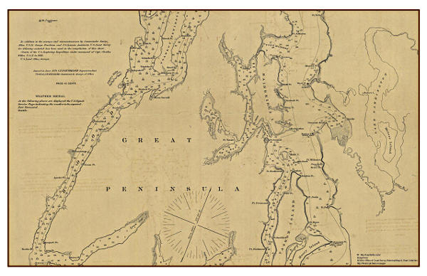
Chart of Seattle and parts of Puget Sound – 1879
1879 Chart of Seattle and parts of Puget Sound
Seattle and the surrounding area, the farthest north point is Pt. Wells north of Shilshole, west to Hood Canal and south with most of Vashon Island.
Download 1879 Chart of Seattle and parts of Puget Sound (PDF 3.2MB)

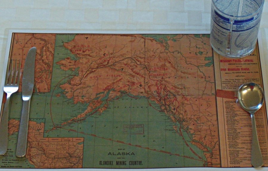
Alaska Klondike Gold Rush Map 1898
Map of Alaska and the Klondike Mining Country from 1898.
Give this one to your friends with Gold Fever or are addicted to watching Gold Rush.
Download the Map of Alaska and the Klondike Mining Country from 1898 (PDF 5.6 MB)
San Juan Islands Chart – 1866
Chart of the San Juan Islands from 1866.
Give this one to your friends that live in the San Juan Islands or like to vacation in the Islands.
The original chart had a white background. I changed the background to transparent then put the chart over a background papyrus paper texture using a publishing program.
Download the 1866 Chart of the San Juan Islands (PDF 1.8MB)

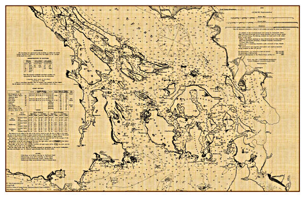
Washington State Map – 1878
Washington State map from 1878.
The proportions of the Washington State map did not match an 11 x 17 inch place-mat. I made a large shape with a papyrus paper background then inserted and centered the map over the new background to give an antique look.
Download Washington State Map from 1878 (PDF 5.2MB)
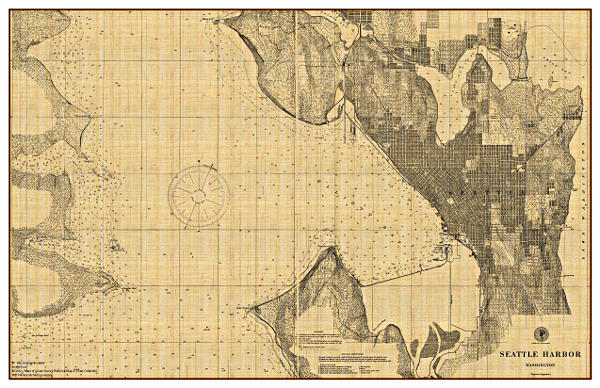
Seattle Harbor Chart – 1901
Seattle Harbor Chart from 1901.
The original chart had a white background. The background was changed to transparent and the the chart laid over a papyrus paper background and the brown border added. This was a difficult chart to convert. The detail in Seattle resulted in very large file sizes. The image needed to be scaled down severely to be manageable. The first PNG file export gave a 134MB file that took almost 1/2 hour of processing time. Scaling the image from 16,300 pixels wide to 4,950 pixels wide with some cropping of the original image still gave a 12 MB PNG file, that was manageable as a transparent overlay.
Download Seattle Harbor Chart from 1901 (PDF 2.7MB)

Marine Disasters Strandings and Wrecks of Vessels on the Coast of Washington
Marine Disasters Strandings and Wrecks of Vessels on the Coast of Washington
NOAA Chart from 1949 showing decades of wrecks off the Coast of Washington.
This is a section of a larger chart that shows Marine Disasters off the Coast of Washington, Oregon and California.
Download Marine Disasters Strandings and Wrecks of Vessels on the Coast of Washington (PDF 8.7MB)
Thanks for dropping by and good luck with the place-mats.
– c / m –


Brilliant idea! I love old maps.
Glad you liked the idea
You might find this article interesting also: https://captnmike.com/2013/11/01/historic-noaa-charts/
Pingback: DIY Gifts for the Holidays | Boating Safety Tips, Tricks & Thoughts from Captnmike