
The difficult struggles NOAA goes through to bring us updated charts were highlighted for Alaska’s Whale Passage. Frequent 7 knot currents, currents so bad that surveys could only be done in one direction, areas last surveyed 100 years ago, projected currents not at all like the actual currents, charted depths twice the actual depths (charted 48 ft. but the actual was only 24 ft.)
Hats off to NOAA for yet another chart update in tough conditions.
by Ensign Sarah Chappel, NOAA Ship Rainier
NOAA Ship Rainier recently surveyed Whale Passage, which separates Whale Island from Kodiak Island, Alaska. The area has never been surveyed with modern full bottom coverage methods, and some project areas were last surveyed by lead lines around a hundred years ago. The area frequently experiences 7 knot currents, making rocky or shoal areas particularly treacherous. Whale Passage is a high traffic area for fishing vessels, U.S. Coast Guard cutters, barges, ferries, and small boats, which is why updating the area’s nautical charts is so important.
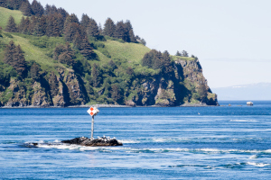 Strong currents push around Ilkognak Rock daymark at the entrance of Whale Passage. (Photo by LTJG Damian Manda)
The dynamics of the passage and surrounding area create several challenges for the hydrographic survey teams. The local tidal and current models are not well-known. To resolve this, Rainier was instructed to install four tide gauges in the…
View original post 372 more words

